|
All underground water originates on the surface of the earth. The heat of the sun evaporates it; it forms clouds and
falls as rain or snow; water accumulates in streams, ponds, oceans and it seeps into the ground. Just how much water is
there underground? Geologists have determined that there is 30 times as much ground water as there is in all the streams,
lakes and rivers in the world!
In the ground, water is found in 3 general types of formations known as an aquifer:
- Layers of sand
- Layers of gravel
- Porous rock or a crack in rock
When drilling equipment is available, it is very tempting to get right to work and drill where drinking water is needed
the most or where the property owner wants the water. While these considerations are important, they should be strongly
resisted; boreholes should be carefully sited, so that drilling only occurs where there is a high
probability of successfully penetrating into water-bearing formations and where boreholes can be effectively used,
maintained, and protected from contamination.
While every borehole will not result in a good drinking water well, advanced planning will maximize the number of
successful boreholes and minimize drilling costs.
In order to successfully site boreholes, those involved must know something about the places where underground water
occurs and how it got there. To identify areas where there is a high probability of successfully drilling boreholes, one
must first prepare a basic map of the site. Consideration must be given to each of the following six factors which
are critical in siting new boreholes:
- Subsurface conditions.
- Subsurface soil types.
- Vegetation.
- Topography.
- Surface water.
- Sources of contamination.
Aerial photographs, geologic reports, borehole logs and topographic maps are useful in studying these factors. Where
available, specialists should be enlisted to use geophysical techniques to define subsurface conditions. This is most
important in areas where air photo coverage and hydrogeological information are inadequate, where local rainfall is
less than 700mm per year and where adequate water supplies are only available in rock. Usually, however, the best source of
borehole siting information is talking to people who have drilled local boreholes and personal inspection of boreholes
in the area. Although this can be time consuming, it is very important and contributes to an understanding of local
subsurface conditions and selection of the best place for successful boreholes.
Groundwater Depth, Quantity & Quality
Where drilled boreholes exist, it is possible to determine the depth to water, geology and expected water quantity and
quality. The history of old boreholes will indicate how far down the water table drops during dry seasons and will indicate
how deep new boreholes must be. If existing boreholes are in the area, the new borehole should be drilled as far away as
possible to ensure that both boreholes will produce sufficient amounts of drinking water without interfering with one
another (drawing water from the same part of the aquifer). Gather as much information possible on surrounding boreholes
before attempting to drill in areas where little information is available or where subsurface conditions are unknown.
In general, the MobiRig rotary drilling rig should be used in
areas where people are getting their water from shallow boreholes (less than 200 feet deep).
Subsurface Soil Types
The quantity (or yield) of an aquifer is as important as its quality. The only way to know exactly how much water is
available in an aquifer (water bearing formation) is by pumping existing or newly constructed boreholes. However, a
rough estimate of yield can be made by identifying the soil and rock which comprise the aquifer.
Most unconsolidated (uncemented) deposits of sand and gravel sized particles contain significant amounts of drinking
water. However, the amount of water which can actually be pumped from these deposits depends on their thickness and
permeability (how easy it is for water to flow through it). In general, the larger the grain size and the thicker the
deposit, the higher the yield of the aquifer.
While sand and gravel deposits usually yield large quantities of water, try to avoid siting and developing boreholes in
shallow sand and gravel deposits if the water table is less than 3 meters below surface. Under these conditions,
waste water can easily infiltrate back down to the water table near the borehole and contaminate the drinking water supply.
Boreholes constructed in silt or clay soils will have very low yields regardless of how they are constructed. To
compensate for this, large 150mm (6inch) diameter boreholes should be drilled so that large volumes of water can slowly
accumulate in the well casing over time and provide sufficient quantities when required. Finally, consolidated rocks,
such as limestone, sandstone or quartzitic rock, may also yield adequate quantities of water. Best yields are found
where there are many cracks (fractures) and a thick zone of weathered rock.
In general, fine grained rocks, such as shale, do not serve as productive aquifers.
Vegetation
During the dry season, survey for indications of groundwater by looking at the alignment of ant mounds and green
vegetation in the midst of an arid landscape. Annual plants, such as grasses and ferns, are not good indicators
because they come and go with the seasons. However, year-round reeds and broad leaf trees and shrubs like cedar and
willow tend to grow where water is close to the surface. Some water indicator trees in Africa are Daniella
(Daniella olivieri), Kapok (Ceiba pentandra) and Baobao (Adansonia digitata).
Topography
The water table commonly follows the land surface (see Figure 1). While the lowest areas
(valley bottoms or depressions where water accumulates after rains) are generally the best places to drill, care must
be taken to ensure that the site has good access, is not subject to flooding and is not close to where contaminated
surface water may pond. The presence of water bearing fracture zones may be detected by surface features such as shallow
linear depressions and abrupt changes in valley alignment. Often these features are difficult to see in the field but
become apparent when viewed from the air or high elevation.
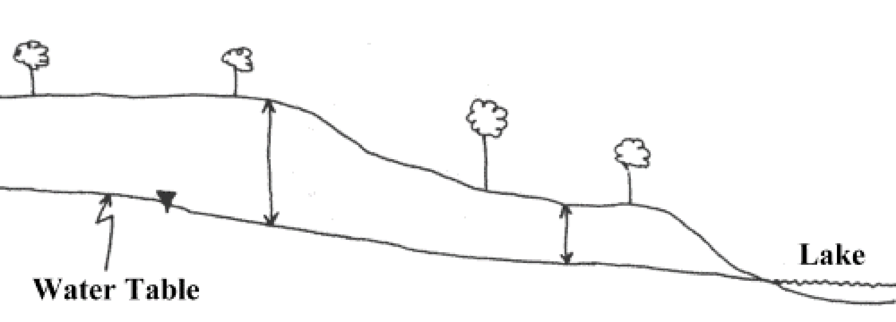
Figure 1: Depth to water
Surface Water
Good boreholes can often be drilled near rivers; if the borehole is deep, groundwater may be available even if the
river is temporarily dry (Figure 2). Reliable boreholes have even been located in or close to broad sandy riverbeds
which are active once every 5-10 years. Water taken from boreholes located at least 15m from a river is usually cleaner
and cooler than water taken from the river. If the borehole water remains turbid after construction, the soils may be
providing inadequate filtration and contaminated river water may be drawn into the borehole.
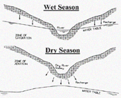
Figure 2: Locating Boreholes Near Rivers
Special consideration should be given to the presence of springs and seeps (wet or marshy areas). Springs on the side of
a hill may indicate the presence of a water bearing formation (aquifer). A successful water borehole can often be
constructed into this aquifer by drilling just uphill of the spring. Animal trails often lead to seeps and springs.
Finally, surface drainage patterns can be used to determine rock type:
- Trellis and rectangular drainage develops where dipping, fractured sedimentary rocks are present;
these are the most favourable areas for high yield aquifers.
- Contorted drainage develops over folded rocks. Water bearing tension fractures and gaps between layers of differing hardness sometimes develop near the top of folds.
- Annular drainage typically develops over volcanic or intrusive (granitic) domes, with streams flowing along
water bearing fracture zones.
- Dendritic or branching patterns with a large number of tributaries are typical of drainage in areas of
impermeable crystalline rock such as gneiss. Parallel drainage patterns may develop in areas with linear
water bearing structures such as faults and dikes.
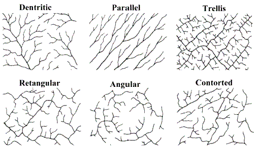
Figure 3: Drainage Patterns
Sources of Contamination
Borehole water should be tested to ensure that it is free from disease-causing organisms and should be clear
and good tasting; otherwise people may revert to traditional unsafe drinking water supplies. This is best accomplished by
avoiding drilling in areas where unsuitable quality water is known to occur and by keeping boreholes as far away as
possible from potential sources of pollution (see Figure 4 and Table 1):
Minimum Separation Distances from Contaminant Sources
| Distance in Meters | Possible Source of Contamination |
| 100 |
Garbage dumps/refuse piles, car repair or fuel (petrol) sales outlets, industrial
operations/storage facilities etc. |
| 50 |
Seepage pit or cesspool |
| 30 |
Pit toilets, animal pens, barns, fields fertilized with dung |
| 15 |
Septic tank, surface water |
| 7 |
Drain or ditch |
Locate boreholes upgradient (uphill) of nearby potential sources of pollution (i.e., the land should NOT slope from
pollution sources towards boreholes). If this can not be avoided, try to locate boreholes as far to the side of the slope
as possible (i.e., not directly downslope of possible contaminant sources).
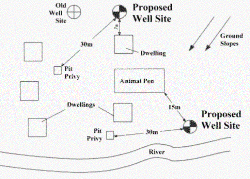
Figure 4: Separation Distances from Contaminant Sources
Preparation of a Site Map
A map of the surrounding area should be prepared. Add to the map all relevant features such as dwellings, animal pens,
pit toilets, rivers, swampy areas, garbage disposal areas and indicate the direction in which the land slopes
(see Figure 4). Draw all possible borehole sites on the map and select the best site.
There is rarely an ideal location and the relative advantages and disadvantages of each site must be weighed. The
drilling contractor and the property owner must together decide which site is best for the borehole. Since selecting
the best site is a matter of judgement and experience, it always helps to seek assistance from hydrogeologists - while
their investigation may be time consuming and add some cost to the drilling project, it will help ensure that a site is
selected which will provide a safe, abundant supply of drinking water.
Sources of Groundwater Information
Information which can help effectively site boreholes includes aerial photographs, geologic reports, borehole logs,
topographic maps, geophysical maps etc. It should be emphasized again, however, that the best source of borehole siting
information is talking to people who have dug local boreholes and personal inspection of boreholes.
Footnotes
The success in siting productive boreholes has improved from 50-60 percent (based on site reconnaissance and air
photo interpretation) to over 90 percent when geophysical technology is used. Geophysical surveys employ instruments that
quickly and cheaply measure the physical properties of soil and rock (density, magnetism, electrical conductivity,
radioactivity etc.). Geophysical surveys can be very useful in locating water-bearing fault zones, in finding an
adequate thickness of overburden or weathered bedrock, and in assessing the depth to the water table. Success depends on
the application of appropriate techniques, having enough time to do the investigation, and having the results interpreted
by trained geologists.
|